Introduction

- NationJapan
- Government NameYamagata Prefecture
- GovernorYoshimura Mieko
Symbol

Emblem

Tree
cherry tree
Bird
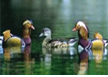
Mandarin Duck

Flower
Safflower

Fish
Cherry salmon
History
- The origins of the name “Yamagata”can be traced back to the early Heian Period (794-1192) of Japan. A dictionary from that period entitled Wamyo Ruijusho refers to the area to the south of what is now Yamagata City as a province called “Yamagata.”At that time, “Yamagata”was written with different kanji(Chinese characters) than it is today, meaning a“place with mountains.”The reason why this area was called Yamagata is unclear, but mountains including Mt. Zao and Mt. Ryuzan that are known for their connection to traditions of mountain spirituality and asceticism can be seen to the south of present day Yamagata City. Yamagata was initially divided into seven separate prefectures, but in 1876 they were joined together to create Yamagata Prefecture in its present form.
Topographic Features
- Location: Yamagata Prefecture is located at the southwest corner of the Tohoku region of Honshu. It’s located about 300㎞ from Tokyo, three hours away from the Yamagata Shinkansen.
- Yamagata, translated to English, means “Mountain Shape,”and as might be expected, there are many famous mountains within the prefecture. In the north, looming over the Shonai coast is Mt. Chokai. Another symbol of Yamagata is the picturesque Mogami River, which wends its way through the heart of the prefecture past Sakata City to the Shonai coast.
Basic Information
| Contents | |
|---|---|
| Geography/Climate |
|
| Population |
|
| Major Events |
|
| Cultural Heritage |
|
| Sisterhood & Friendship Provinces / Cities |
|
Economic Status
| Contents | |
|---|---|
| Economy |
|
| Industry |
|
| Products |
|
Others
- Contact:Ministry of Commerce and Tourism, Bureau of Tourism Economy Exchange, Department of Economic Exchange, International Office
- Address: 山形県 山形市 2-8-1
- Tel.:+81-23-630-2116
- Fax.:+81-23-624-9908
- Official Website : http://www.pref.yamagata.jp