Introduction

- NationJapan
- Government NameAkita Prefecture
- GovernorSzuki Kenta
Symbol

Emblem

Tree
Akita-Japanese Cedar

Bird
Yamadori (Copper pheasant)

Flower
Butterbur
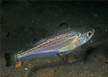
Fish
Sailfin sandfish
History
- The name Akita is first described in the Nihon Shoki which contains records of the naval advancement led by Abe no Hirafu in 658.
- Origins of the Current Local Government : The present day Akita Prefecture was born through the merging of Kameda, Yashima, Iwasaki, Honjo, and Akita prefectures with Gakasumi County of Esashi District by reorganization of administration in 1871.
Topographic Features
- Akita Prefecture is located approximately 450km north of Tokyo on the east coast of Japan. Its total area is 11,637.52㎢ and the administrative district is divided into 13 cities, 9 towns, and 3 villages.
- With Mount Okuvane at the center, Akita Prefecture is bordered by Iwate in the east, Yamagata and Miyagi in the south, Aomori in the north, and the East Sea in the west. Furthermore, located on the boundary of Aomori and Akita is the Lake Towada national park.
Basic Information
| Contents | |
|---|---|
| Geography/Climate |
|
| Population |
|
| Cultural Events |
|
| Cultural Heritage in Major Tourist Sites |
|
| Sisterhood & Friendship Provinces / Cities |
|
Economic Status
| Contents | |
|---|---|
| Economy |
|
| Industry |
|
| Products |
|
Others
- Contact:Service Department : International Division of Planning and Promotion Department
- Address: 秋田県秋田市山王 4-1-1
- Tel. : +81-18-860-1218
- Fax. : +81-18-860-3874
- Official Website : https://www.pref.akita.lg.jp/